News
Historic Records Register
We have a new Historic Records Viewer available on Canterbury Maps! This is an interactive application built to share our history.
Environment Canterbury has a large collection of historical records from around the region. The records include oblique and aerial photographs, plans, river and drainage classification, land survey data and building and structure plans. Each document is marked by a point or area to indicate the location that the record refers to.
Follow the step-by-step instructions below to view and download desired records. Please read the about information (found in the top right corner of the application), before downloading.
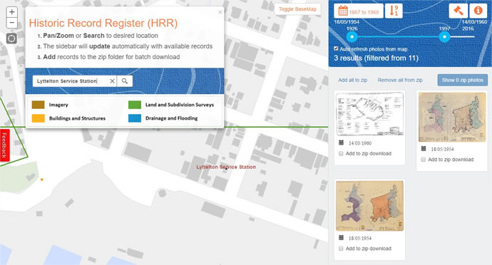
- Find your location of interest by using the pan/zoom or search functions.
- The sidebar will update automatically with avaiable records within your search area.
- You can preview records by selecting a thumbnail in the sidebar.
- Documents can also be sorted and filtered by date in the side bar menu.
- Add records to the zip folder for batch download.
A couple things to note.....
- Records have been mapped to varying degrees of accuracy and the markers may therefore not represent the exact location. The point layer suggests a higher level of confidence in locating the document, than the area features.
- This viewer only contains a subset of the records held by Environment Canterbury.
We welcome your feedback – Let us know what you are interested in seeing in the Canterbury Historic Plans Register; how easy you have found it to use; any comments you would like to make to help us make it a valuable tool for you.
All data unless specifically stated is licensed under a Creative Commons Attribution 3.0 New Zealand License.
